Scan to BIM services
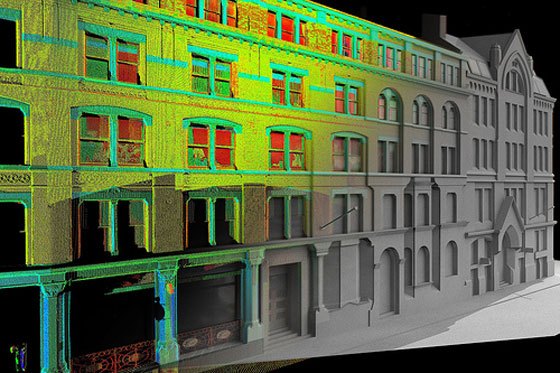
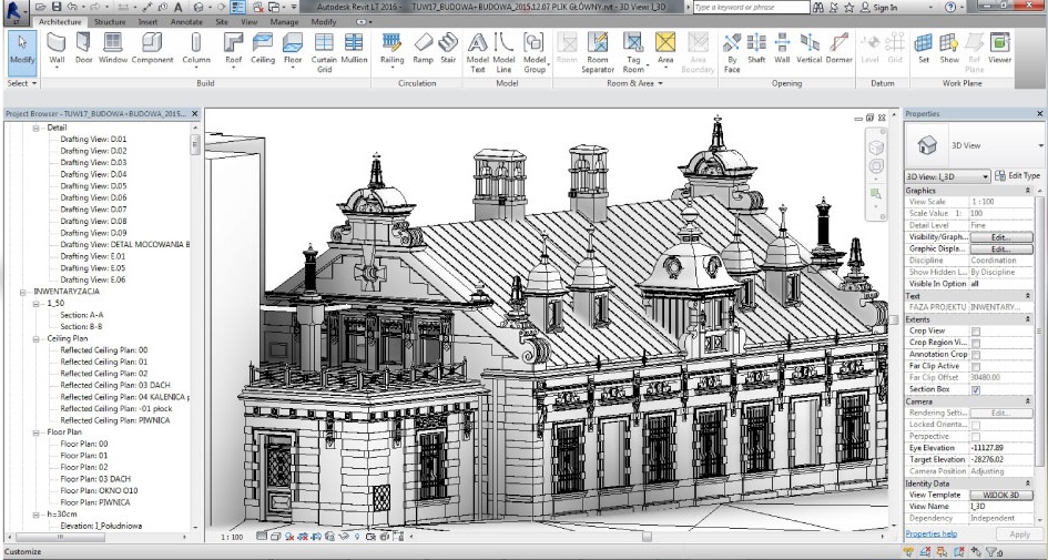
Design Source India provides highly accurate and reliable scan to Revit BIM 3D modeling services. We use the latest technology to extract( each and every minute details) available in the market to convert point clouds and lazer scans into sophisticated BIM models. We take advantage of faces available in Revit for new and renovated areas. The scan to bIM model can be used for as built services. Our expertise lies in the process of getting Model from lazer point cloud data. Our team of highly experienced engineers and modelers create not only accurate BIM models but also information rich intelligent as-built models the intelligence embedded in the model provides information related to construction conditions and cost.
Revit BIM Modeling Process at Design Source India
With Latest technology highly experience driven process through the million of points. it is the modelers experience and understanding which guides him to build accurate point cloud models relevant to the site. As it is the point cloud data contains lot of inconsistencies which need to be dealt with before starting scan to BIM process. Our team at India the develop point cloud for Revit BIM view of a complete Scan to BIM services for architectural structure commercial buildings.
We also provide specialized mechanical Electrical plumbing point cloud to 3D model Services. Point cloud Heritage buildings scan to BIM renovation refurbishment and retrofit projects.
Not only we provide scan to BIM services but we can include your designs and proposed retrofitting to the site. We provide best scan to BIM documentation services for your project. 3D laser scanning to BIM services popular with Scanning Engineer, mep Consultants, facility manager and Architects. The point cloud modeling allows accurate as built condition surveys as compared to traditional measured surveys. The architectural model includes all elements including BIM ceiling columns Truss roofs flooring internal walls and landscape elements scan to BIM MEPF elements include plumbing pipes ducks and various other mechanical models.
Our laser scanning to BIM conversion team uses three layer quality check parameters which not only develop accurate but also conduct a rigorous design validation for the Model elements. Design Source India 3D laser scanning to be model fully loaded with information including quantity takeoff material schedules and cost estimation details the scan to be models are visually ready for 3 documentation and rendering. our company Delivers high value BIM services thus garnering appreciation and building long term business relations with the clients.
Scan to BIM Interiors projects using Mobile Scanner:
The primary function of the Mobile scanner is very similar to a terrestrial scanner. If you aren't sure how the mobile scanner works or laser scanning in general, please go to our Laser scanning section.
How you can capture Interiors through Mobile Scanner?
Now because with mobile scanner, you don't need to set it up on a tripod for each scan and register all the scans together. Mobile scanners can scan as they move through out the 3d space. That means, all you need to do is hold the Mobile scanner out in front of you and walk through the entire space and you can capture the entire environment in 3d.
What does a Mobile Scanner look like?
If we take a closer look at the scanner itself. You can see that the entire scanning system and all the moving parts are protected, underneath the dome at the top of the device. The MOBILE SCANNER also has four (depending on the model) cameras around the outside. Three of these cameras are constantly taking images as you move, and these images are used for tracking, creating panoramic images and colorizing the point cloud. The fourth camera is on the front, and this is the detail camera. The detail camera is used for taking images of specific things that you need more detail of because the mobile scanner needs to track itself through 3d space. This is where slam comes into play.
What is SLAM (simultaneous localization and mapping) in Laser scanning.
Slam stands for simultaneous localization and mapping. This is a technical term for tracking something through 3d space. The Mobile scanner actually uses three different methods of SLAM to be as accurate as possible.
First off, it has an internal IMU, which stands for inertial measurement unit. This calculates the movement of the Mobile scanner by physically sensing motion.
Secondly, it'll use those three cameras to track what it can physically see and calculate its own movement. This is called Visual slam. And lastly, it will use LIDAR slam, which is the process of finding stationary surfaces in the LIDAR data and using this to calculate the Mobile scannermovement.
All three of these slam techniques allow the Mobile scanner to track itself through the environment, so you can scan while you walk without ever needing to stop. Now you can scan with the Mobile scanner all by itself,
Mobile app for laser scanning to view live data capture
But there is a Mobile scanner live app that allow you to see a live stream of the data that you're capturing. You can view the cloud in 2d or 3d, which is extremely valuable to make sure you don't have any areas with missing data. And of course, this app will let you monitor essential info like battery life and available storage space.
Why use Mobile scanner for Interiors.
The most obvious advantage to using a mobile scanner is the scanning process, is much easier, and it's a lot faster than using a terrestrial scanner. It also removes a lot of the manual post processing work that's required by terrestrial scanners,
Specification of good mobile scanner for Interior projects?
The working range of the Mobile scanner should be around 25 meters, which is about 80 feet. While you're scanning, you should be able to scan about 45 minutes on a single battery before you need to swap it out. The internal storage space on the Mobile scanner home should be about six hours of scanning.
What should be the ideal density of points for Interior Projects?
the Mobile scanner should scan at about 400,000 points per second. And being a mobile scanner, the density of your points is largely going to depend on how fast you walk through an area. If you need more density, and more detail. All you need to do is slow down, and the scanner is going to capture way more points in that particular area.
So that was a quick overview of the mobile. If you have any questions, please contact us through our contact form or write directly to us at info@designsourceindia.com


